
Based on press release issued by Think City, Due to global pandemic and Movement Control Order, in result Clear Skies seen in Malaysia As Lower Levels of Nitrogen Dioxide.
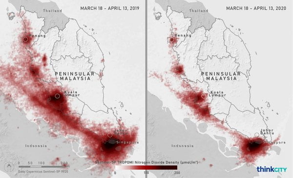
These maps show the nitrogen dioxide (NO2) levels in Peninsular Malaysia during March 18-April 13, 2019 (left) and March 18-April 13, 2020 (right). The maps where produced by Think City from spectrometry data obtained from Copernicus Sentinel-5P European Space Agency satellite.
A dramatic reduction in nitrogen dioxide levels has become evident in Peninsular Malaysia since the Movement Control Order (MCO) was put into place on March 18, 2020. Maps produced by Think City’s Analytics Department using satellite spectrometry data, show that the skies above Malaysia, and in particular over Johor Bahru and Kuala Lumpur, have significantly lower levels of nitrogen dioxide from vehicle emissions.
Nitrogen dioxide is produced by the burning of fossil fuels such as coal, oil and gas, with about 80% coming from motor vehicle exhaust fumes. Breathing in this gas inflames lungs and leads to respiratory problems while increasing the likelihood of infections. The reduction in its levels in Malaysia can be directly attributed to people being less mobile, with a fall in the use of motorised vehicles. Similar patterns can be seen in Europe, China and the USA.
Photo Credit : Trover
Think City Programme Director Dr Matt Benson said that cleaner air in Malaysian cities was an unintended consequence of the Movement Control Order, related to the COVID-19 pandemic:
“As we are forced into hibernation, our cities are changing in ways we hadn’t thought possible. Think City’s mapping of changes in nitrogen dioxide between now and this time last year shows that as Malaysians move about less due to the MCO there are reduced vehicle emissions. This is particularly evident along the west coast of Peninsular Malaysia, which is where 20 million people reside.”
Dr Benson added that due to the complex nature of cities and societies, data is a key weapon in fighting the COVID-19 crisis.
“Not only would data help manage the disease itself but also help us keep track of, and even plan ahead of, the social and economic consequences, he said.
Think City Analytics Lead, Dr Ceelia Leong, said that the team had been working tirelessly in the weeks following the MCO to compile up-to-date data across a range of different areas to be analysed and incorporated into policy responses.
“We have just launched a COVID-19 Community Resilience mapping tool, which looks at a number of social, economic and even environmental variables to offer insights into which areas may need additional public health, economic or social welfare assistance,” Dr Leong said.
“For the rest of the MCO and beyond, we will continue to use data mapping tools, which we have developed inhouse, to offer even further insights on the impact of COVID-19 on Malaysia – how people are faring and which places or groups require attention and action,” she added.
“We will also be releasing related maps and findings regularly on our social media platforms.”
The COVID-19 Community Resilience tool visualises data highlighting the places and communities which are the most vulnerable to the current and potential impacts of COVID-19 in Malaysia. This tool can help users understand the complexity of impacts by overlapping different socio-economic and health data to assess areas of higher vulnerability and identify under-supported communities.
The tool aims to contribute to the development of national, state, and local response strategies to increase the resilience of vulnerable communities in Malaysia through effective resource allocation.
The COVID-19 Community Resilience mapping tool is available online via Think City’s Urban Analytics Portal: https://thinkcity.com.my/urban-analytics/.
Source : Think City


")